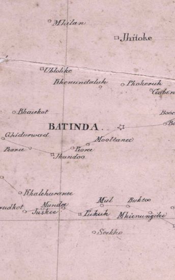
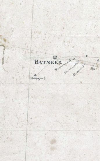
PUNJAB Map of the country South of the Suthludj River between Lodianah Bhuttindah, and ferozepoor, Surveyed in 1835. Copied by Shaikh Khadem Ally in 1835.
| Department | Survey Of India (Maps) |
| From Year / Date (YYYY-MM-DD) |
1835 |
| To Year / Date (YYYY-MM-DD) |
1835 |
| Place | Punjab |
| Series | Historical Maps |
| Identifier | CR_000002286564 |
| File No. | F10-22 |
| Scale | 1 - 4 miles |
| File Size | 7.2 MB |
| Pages | 1 |
| Collection | Digitized Cartographic Records |
| Series | Historical Maps |
-
1063 views
Other Similar Items
-
- 692 Views
- Supply of 5 copies of the Report on the Reconnaiss...
- Department: Foreign
- Branch: External-B
- Year / Date: 1892
-
- 446 Views

- Reappropriation of a sum of Rs 106-13-10 from the ...
- Department: Foreign
- Branch: External-B
- Year / Date: 1904
-
- 424 Views
- PUNJAB Map of the Trans.Indus Frontier of th ePunj...
- Department: Survey Of India (Maps)
- Year / Date: 1848
-
- 251 Views
- Jungle Terry Size: 52 cmx74cm between borders in o...
- Department: Survey Of India
-
- 500 Views
- Request made by the Resident in Waziristan for the...
- Department: Foreign
- Branch: Frontier-B
- Year / Date: 1893
-
- 403 Views
- DELHI (Map of the Country between Delhi and Lundia...
- Department: Survey Of India (Maps)
- Year / Date: 1808
-
- 339 Views
- DELHI Map of the Country between Delhi and Lundian...
- Department: Survey Of India (Maps)
- Year / Date: 1808
-
- 2920 Views
- PUNJAB Map of the Norethern Frontier of British In...
- Department: Survey Of India (Maps)
- Year / Date: 1844
-
- 325 Views
- Correspondence regading the Naresh Kot Radha Kisha...
- Department: Foreign and Political
- Branch: External-B
- Year / Date: 1914
-
- 220 Views
- Peshawar Size: 42.6 cm x 60.7 cm, between borders...
- Department: Survey Of India (Maps)