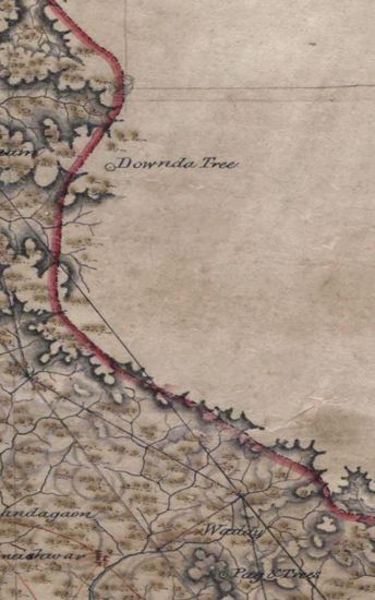
Hyderabad Size of the map , in 5 sections, is 110 cm x 358 cm, actual area; on tracing cloth . Latittudes from 19024’N to 19048’N and longitudes from 770E to 790E marked and numbered; hand- drawn and beautifully colored; forest and cultivated areas , coconut tree groves artistically drawn; high table lands and mountain ranges nicely shown in burnt sienna with grey tints; sites of places drawn in a peculiar fashion but artistically designed; routes drawn in a peculiar fashion but artistically designed ; routes drawn in single lines of burnt sienna ; lines of triangulations all along the borders shown in black ink; some graticules, in red ink, also marked, and bears the the signature of Lt. Col. H.L. Thuillier, Surveyor General of India.
| Department | Survey Of India (Maps) |
| Place | Hyderabad |
| Series | Cartographic Notes |
| Identifier | CR_000002286609 |
| File No. | 1841-60-19(C) |
| Scale | 110 cm x 358 cm |
| File Size | 12.4 MB |
| Pages | 1 |
| Collection | Digitized Cartographic Records |
| Series | Cartographic Notes |
-
309 views
Other Similar Items
-
- 295 Views
- Hyderabad Size of the map , in 5 sections, is 110 ...
- Department: Survey Of India (Maps)
-
- 352 Views

- Hyderabad Size of the map , in 5 sections, is 110 ...
- Department: Survey Of India (Maps)
-
- 390 Views
- Kashmir Size 51.1 cm x 63. 3 cm, between borders; ...
- Department: Survey Of India (Maps)
-
- 344 Views

- Dindigul Sizes of various sections very between 33...
- Department: Survey Of India (Maps)
-
- 290 Views
- Tinnevelly Size: 57 cm x 65 cm , actual area; two ...
- Department: Survey Of India
- Year / Date: 1813
-
- 273 Views

- Tinnevelly Size: 80 cm x 89.5 cm, actual areas; in...
- Department: Survey Of India
- Year / Date: 1811
-
- 318 Views
- Sylhet Size: 98.3 cm x 91.5 cm, between borders; i...
- Department: Survey Of India (Maps)
-
- 343 Views

- Tinnevelly Size: 80 cm x 96cm,actual area; five sh...
- Department: Survey Of India (Maps)
- Year / Date: 1810
-
- 377 Views

- Tinnevelly Size: 80.5 cm x 66cm, actual areas tree...
- Department: Survey Of India
- Year / Date: 1805
-
- 289 Views

- Tinnevelly Size: 79 cm x 57.5 cm , actual areas th...
- Department: Survey Of India (Maps)
- Year / Date: 1805