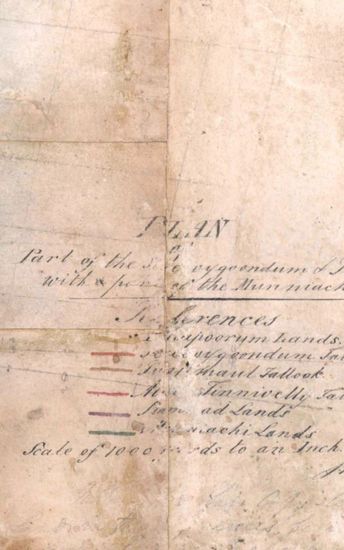
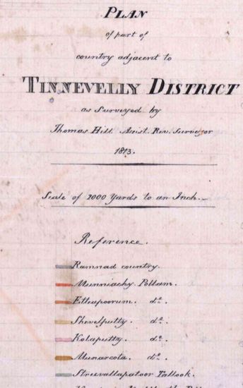
Tinnevelly Size: 97cm x 100.5 cm , actual area; two sheets pasted together. No cordinates marked or numbered ; hand -drawn and lightly coloured ; boundaries ribbon- coloured with rougly drawn circles and rectangles in light burnt sienna; rocks in the sea near the coast beautifully shown palmyras groves decoratively drawn; releif shown by grey tint; roads marked with single lines of burnt sienna with trees lines on both sides; blank areas also marked; lines of triangulation marked with black; sites of 'Deserted village'. Salt pans' 'Parcharry' and 'Choultry' marked on the eastern coast line. A nearly drawn map . Watermark: J WHATMAN 1801.
| Keywords | Thomas Hill |
| Department | Survey Of India (Maps) |
| From Year / Date (YYYY-MM-DD) |
1810 |
| To Year / Date (YYYY-MM-DD) |
1810 |
| Place | Tinnevelly |
| Series | Cartographic Notes |
| Identifier | CR_000002286493 |
| File No. | 1801-20-19(Q) |
| Scale | 97cm x 100.5 cm |
| File Size | 11.2 MB |
| Pages | 1 |
| Collection | Digitized Cartographic Records |
| Series | Cartographic Notes |
-
341 views
Other Similar Items
-
- 286 Views
- Tinnevelly Size: 77cmx 83 cm, actual areas ; four ...
- Department: Survey Of India
- Year / Date: 1805
-
- 377 Views

- Tinnevelly Size: 80.5 cm x 66cm, actual areas tree...
- Department: Survey Of India
- Year / Date: 1805
-
- 273 Views

- Tinnevelly Size: 80 cm x 89.5 cm, actual areas; in...
- Department: Survey Of India
- Year / Date: 1811
-
- 289 Views

- Tinnevelly Size: 79 cm x 57.5 cm , actual areas th...
- Department: Survey Of India (Maps)
- Year / Date: 1805
-
- 290 Views
- Tinnevelly Size: 57 cm x 65 cm , actual area; two ...
- Department: Survey Of India
- Year / Date: 1813
-
- 318 Views
- Sylhet Size: 98.3 cm x 91.5 cm, between borders; i...
- Department: Survey Of India (Maps)
-
- 343 Views

- Tinnevelly Size: 80 cm x 96cm,actual area; five sh...
- Department: Survey Of India (Maps)
- Year / Date: 1810
-
- 241 Views

- Goa size: 89 cm x 61 cm, between borders ; in one ...
- Department: Survey Of India
- Year / Date: 1814-05-29
-
- 226 Views

- Goa Size: 91.5 cm x62.5 cm, betwwen borders; in on...
- Department: Survey Of India
- Year / Date: 1811
-
- 220 Views
- Tinnevelly Size: 82 cm x 86.5 cm, between boprders...
- Department: Survey Of India
- Year / Date: 1812