16 Items found in 0.027 seconds
Results
-
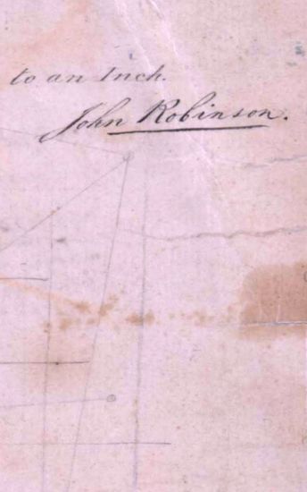
- Tinnevelly Size: 73cmx 54cm ,actual areas; in one sheet .No coordinates marked or numbered; hand-drawn and coloured; cultivated fields drawn with light green rectangles an uncultivated fields shown with burnt sienna; hedges around the fields shown with deep green; relief marked with grey tint; roads in thin single lines ofburnt sienna with trees lined on both sides ; blank areas shown; and triangulation lines in black ink. Watermark: S WISE & PATCH with 'Fleur -de-Lis ' and year 1805 below it.
- Department: Survey Of India (Maps)
- Year: 1805
- Place : Tinnevelly
- Keywords : John Robinson
- Digitized Collection : Digitized Cartographic Records
- Held by : National Archives of India
- Date of Upload: 2018-01-06
- 319 Views
-
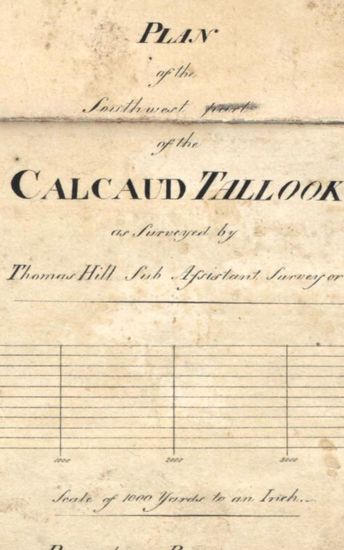
- Tinnevelly Size: 97cm x 100.5 cm , actual area; two sheets pasted together. No cordinates marked or numbered ; hand -drawn and lightly coloured ; boundaries ribbon- coloured with rougly drawn circles and rectangles in light burnt sienna; rocks in the sea near the coast beautifully shown palmyras groves decoratively drawn; releif shown by grey tint; roads marked with single lines of burnt sienna with trees lines on both sides; blank areas also marked; lines of triangulation marked with black; sites of 'Deserted village'. Salt pans' 'Parcharry' and 'Choultry' marked on the eastern coast line. A nearly drawn map . Watermark: J WHATMAN 1801.
- Department: Survey Of India (Maps)
- Year: 1810
- Place : Tinnevelly
- Keywords : Thomas Hill
- Digitized Collection : Digitized Cartographic Records
- Held by : National Archives of India
- Date of Upload: 2018-01-06
- 341 Views
-
- Tinnevelly Size: 87 cmx 29 cm, between borders; in one sheet. Parallels from 8 Nto 10 N and meridians from 77 10 'E to77 50 E marked and numbered ; hand- drawn and coloured; general conventional sign used to show toppograhical feautures; mountains shown with grey tintand roads in single lines of burnt sienna.
- Department: Survey Of India (Maps)
- Year:
- Place : Tinnevelly
- Digitized Collection : Digitized Cartographic Records
- Held by : National Archives of India
- Date of Upload: 2018-01-06
- 230 Views
-

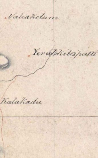
- Tinnevelly Size: 80 cm x 96cm,actual area; five sheets pasted together. No coordinates marked or numbered; hand- drawn and coloured; cultivated fields shown by roughlydrawn small rectangles of various sizes and shapes with burnt seinna; poolembankments marked with black lines ; palmyras, bamboo and cocoanutgroves shown with different symbols; boundaries ribbon- coloured; releif shown by grey and red tints; roads in single lines of light burnt sienna; blank areas shown; triangulation lines in black ink, and graticules in pencil also visible.
- Department: Survey Of India (Maps)
- Year: 1810
- Place : Tinnevelly
- Keywords : Thomas Hill
- Digitized Collection : Digitized Cartographic Records
- Held by : National Archives of India
- Date of Upload: 2018-01-06
- 343 Views
-

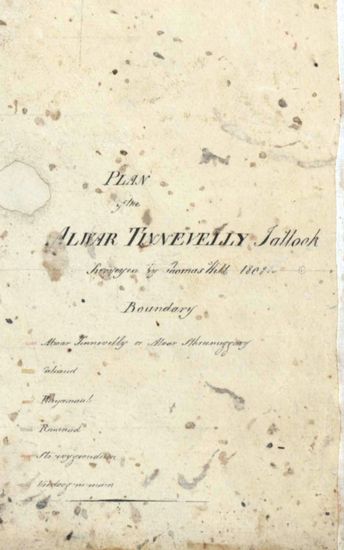
- Tinnevelly Size: 79 cm x 57.5 cm , actual areas three sheets pasted together .No coordinates marked or numbered; hand-drawn and coloured ; cultivated areas shown by roughly drawn rectangles of various sizes and shapes in burnt sienna; releif shown by grey tint; roads marked as thick single lines of burnt sienna with trees lined on both sides; 'Halting Stations' on routes numbered ; blank areas shown ;and triangulation lines in black ink. A rougly drawn map. Watermark: S WISE & PATCH with 'Fleur- de- Lis ' and year 1805below it.
- Department: Survey Of India (Maps)
- Year: 1805
- Place : Tinnevelly
- Digitized Collection : Digitized Cartographic Records
- Held by : National Archives of India
- Date of Upload: 2018-01-06
- 289 Views
-
- Tinnevelly Size: 65 cm x 81 cm, actual areas ;in one sheet . No coordinates marked or numbered ; hand -drawn and sparsely coloured; boundaries ribbon -coloured; cultivated areas shown as rectangles with grey and black lines; forests marked with trees drawn in black with shadows on the east; relief shown by grey tint and roads in thick single lines of burnt sienna; blank areas appear; and tiangulation lines in black ink with distances in feet. A neatly finished map. Watermark:J WHATMAN 1801.
- Department: Survey Of India (Maps)
- Year: 1801
- Place : Tinnevelly
- Digitized Collection : Digitized Cartographic Records
- Held by : National Archives of India
- Date of Upload: 2018-01-06
- 261 Views
-
- Tinnevelly Size: 77 cm x 84.5 cm , actual areas ; two sheets pasted together . No coordinates marked or numbered; topogrphical detail similar to those on sheet 1801-20-19F. Watermark: S WISE & PATCH with ' Fleur -de-Lis ' and the year 1805 below it.
- Department: Survey Of India
- Year: 1801
- Place : Tinnevelly
- Keywords : Thomas Hill
- Digitized Collection : Digitized Cartographic Records
- Held by : National Archives of India
- Date of Upload: 2018-01-06
- 227 Views
-

- Tinnevelly Size: 80 cm x 80cm, actual areas; four sheets of unequal sizes pasted together. No coordinates marked or numbered ; cartographic details similar to those on sheet 1801 -20/19F except releif, shown by grey tint with vertical hechures of black. Watermark: S WISE &PATCH CO WITH 'Fleur- de- Lis' and year 1805below it.
- Department: Survey Of India
- Year: 1808
- Place : Tinnevelly
- Keywords : Thomas Hill
- Digitized Collection : Digitized Cartographic Records
- Held by : National Archives of India
- Date of Upload: 2018-01-06
- 234 Views
-

- Tinnevelly Size: 80.5 cm x 66cm, actual areas tree sheet pasted together. NO coordinates marked or numbered; hand drawn and coloured; blank areas appear; swamps shown as grey horizontal rough brush strokes on light blue tint; forests represented by thick ,closely placed green dots, a very unconventiona way ; palmyras bamboo and cocoanut groves beautifully drawn; releif marked by grey tint; roads in thick single lines of burnt sienna ;triangulation lines marked and distances, bet ween two stations, marked on the lines in feet; graticules shown in pencil and also some place4 -names probably added later. Watermark: S Wise & PATCH 1805
- Department: Survey Of India
- Year: 1805
- Place : Tinnevelly
- Digitized Collection : Digitized Cartographic Records
- Held by : National Archives of India
- Date of Upload: 2018-01-06
- 377 Views
-
- Tinnevelly Size: 77cmx 83 cm, actual areas ; four sheets of unequal sizes pasted together.No coordinatesmarked or numbered; hand -drawn and coloured; blank areas appear; forest areas marked by green dots and swamps by green and black smaller dots ;cultivated areas shown as rectangles of burnt sienna ; palmyras groves represented by beautiful symbols; boundaries ribbon -coloured; releif shown by grey tint and roads marked by thick single lines of light sepia ; lines of triangulations marked ; site of Romn .Church south of Tuticorin marked; and salt godowns, chaultry and parchary sites also marked. Watermark: 'S WISE & PATCH 1805.
- Department: Survey Of India
- Year: 1805
- Place : Tinnevelly
- Digitized Collection : Digitized Cartographic Records
- Held by : National Archives of India
- Date of Upload: 2018-01-06
- 286 Views
-
- Tinnevelly Size: map 19G: 84.5 cm x 100cm, actual areas 4sheets pasted together; map 19H: 73.5 cm x 65 cm actual area; in one sheet. No coordinates marked or numbered ; hand -drawn and coloured; blank areas appear; topographical detail similar to those of map 1801-20/19F; on map 19H ,major trianglation lines in red and minor ones in dotted red. Watermark : map 19G-J WHATMAN 1801 MAP 19H - S WISE&PATCH 1803.
- Department: Survey Of India
- Year:
- Place : Tinnevelly
- Digitized Collection : Digitized Cartographic Records
- Held by : National Archives of India
- Date of Upload: 2018-01-06
- 211 Views
-

- Tinnevelly Size: 80 cm x 89.5 cm, actual areas; in one sheet. No coordinates marked or numbered ; hand -drawn and coloured ; towns and cultivated areas drawn with light burnt sienna ; boundaries ribbon -coloured ; palmyras groves marked with typical symbol s; rocky areas shown as'rock'; releif shown with grey tint; roads drawn with thick singlelines of burnt sienna with dark green dots on both sides as trees; lines of triangulations drawn in black ink and graticules in pencil; 'Choultry' and 'Paracherry' sites also shown.
- Department: Survey Of India
- Year: 1811
- Place : Tinnevelly
- Keywords : Thomas Hill
- Digitized Collection : Digitized Cartographic Records
- Held by : National Archives of India
- Date of Upload: 2018-01-06
- 273 Views
-
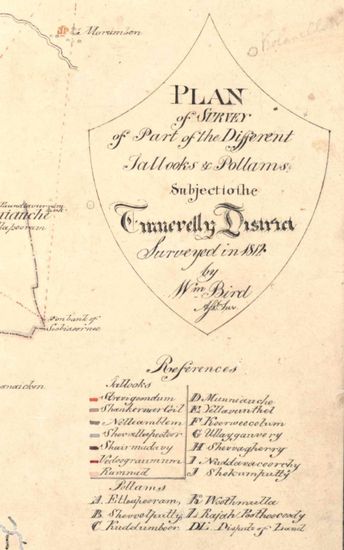
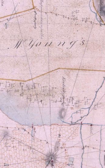
- Tinnevelly Size: 82 cm x 86.5 cm, between boprders; two sheets pasted together. No coordinates marked or numbered ; palmyras groves and towns marked with unconventional symbols; forest areas shown with spray of green and grey coloures; embankments on lakes marked with thick burnt sienna dot; releif shown by hair- like vertical hechures drawn with semi dry brush of grey colour; roads in single lines of light burnt sienna, and lines of triangulations marked with dotted lines of light burnt sienna.
- Department: Survey Of India
- Year: 1812
- Place : Tinnevelly
- Keywords : Win Bird
- Digitized Collection : Digitized Cartographic Records
- Held by : National Archives of India
- Date of Upload: 2018-01-06
- 220 Views
-

- Tinnevelly Size: 82 cm x 126.5 cm , actual areas ; three sheets pasted together. No coordinates drawn or numbered; hand-drawn in black ink and coloured ; unconventional symbols used for topographical details; releif shown bygrey tint; roads in single lines of sepia; lines triangulations marked ;sites of 'Salt Godown ' and 'Parchary' also shown. Two watermarks on the sheets: (1) J WHATMAN1808, (2) J WHATMAN1804.
- Department: Survey Of India
- Year:
- Place : Tinnevelly
- Keywords : John Robinson
- Digitized Collection : Digitized Cartographic Records
- Held by : National Archives of India
- Date of Upload: 2018-01-06
- 240 Views
-
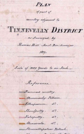
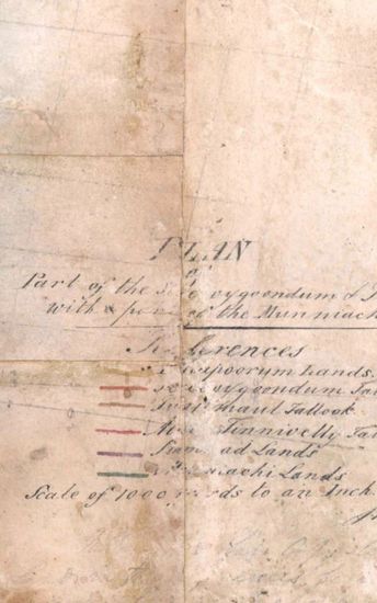
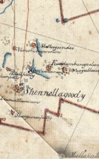
- Tinnevelly Size: 57 cm x 65 cm , actual area; two sheets pasted together. No coordinates marked or numbered; hand-drawn in black ink and coloured; boundaries ribbon -coloured ; palmyras groves beautifully drawn using uncoventional signs; releif shown by grey tint; roads in single lines of burnt sienna; lines of triangulations also marked ; some place- names and graticules in pencil with mathematical calculations and tables .also in pencil but faintly visible in the right bottom corner. Watermark: N ot clearly visible.
- Department: Survey Of India
- Year: 1813
- Place : Tinnevelly
- Keywords : Thomas Hill
- Digitized Collection : Digitized Cartographic Records
- Held by : National Archives of India
- Date of Upload: 2018-01-06
- 290 Views
-
- Tinnevelly Size: 37 cmX 48 cm, actual areas; three sheets pasted together. No coordinates marked or numbered; hand- drawn in blavk and coloured; boundaries ribbon -coloured; releif shown by grey tint; roads in single lines of burnt sienna; lines of triangulations marked; tittle and 'Reference' to colours given in pencil. Watermark: J WHATMAN1801
- Department: Survey Of India
- Year: 1801
- Place : Tinnevelly
- Digitized Collection : Digitized Cartographic Records
- Held by : National Archives of India
- Date of Upload: 2018-01-06
- 249 Views
-
- 319 Views
- Tinnevelly Size: 73cmx 54cm ,actual areas; in one ...
- Department: Survey Of India (Maps)
- Year: 1805
-
- 341 Views
- Tinnevelly Size: 97cm x 100.5 cm , actual area; tw...
- Department: Survey Of India (Maps)
- Year: 1810
-
- 230 Views
- Tinnevelly Size: 87 cmx 29 cm, between borders; in...
- Department: Survey Of India (Maps)
-
- 343 Views
- Tinnevelly Size: 80 cm x 96cm,actual area; five sh...
- Department: Survey Of India (Maps)
- Year: 1810
-
- 289 Views
- Tinnevelly Size: 79 cm x 57.5 cm , actual areas th...
- Department: Survey Of India (Maps)
- Year: 1805
-
- 261 Views
- Tinnevelly Size: 65 cm x 81 cm, actual areas ;in o...
- Department: Survey Of India (Maps)
- Year: 1801
-
- 227 Views
- Tinnevelly Size: 77 cm x 84.5 cm , actual areas ; ...
- Department: Survey Of India
- Year: 1801
-
- 234 Views
- Tinnevelly Size: 80 cm x 80cm, actual areas; four ...
- Department: Survey Of India
- Year: 1808
-
- 377 Views
- Tinnevelly Size: 80.5 cm x 66cm, actual areas tree...
- Department: Survey Of India
- Year: 1805
-
- 286 Views
- Tinnevelly Size: 77cmx 83 cm, actual areas ; four ...
- Department: Survey Of India
- Year: 1805
-
- 211 Views
- Tinnevelly Size: map 19G: 84.5 cm x 100cm, actual ...
- Department: Survey Of India
-
- 273 Views
- Tinnevelly Size: 80 cm x 89.5 cm, actual areas; in...
- Department: Survey Of India
- Year: 1811
-
- 220 Views
- Tinnevelly Size: 82 cm x 86.5 cm, between boprders...
- Department: Survey Of India
- Year: 1812
-
- 240 Views
- Tinnevelly Size: 82 cm x 126.5 cm , actual areas ;...
- Department: Survey Of India
-
- 290 Views
- Tinnevelly Size: 57 cm x 65 cm , actual area; two ...
- Department: Survey Of India
- Year: 1813
-
- 249 Views
- Tinnevelly Size: 37 cmX 48 cm, actual areas; three...
- Department: Survey Of India
- Year: 1801